Columbia Icefield Region
One of the most famous icefields in the world, though certainly not anywhere near the biggest, the Columbia Icefield straddles the Continental Divide between Alberta and British Columbia, as well as the boundary between Banff and Jasper National Parks. Perhaps ironically, most of it is not actually visible from the Icefields Parkway itself, because it is an ice cap located behind most of the mountain slopes visible from the road. The icefield is the source from which many of the famous glaciers of the Canadian Rockies flow. This sceneset includes views of mountains and glaciers in the area, including images from a visit out onto the ice of Athabasca Glacier, some shots from a climb up Parker Ridge, and some images from the more northern reaches of the Icefields Parkway.
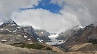
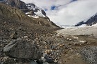
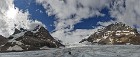
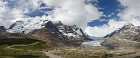
1 The Columbia Icefield This wide panorama gives you a general view of the lay of the land near the Icefields Visitors' Centre, located near the border between Banff National Park and Jasper National Park. In the background, from left to right: Mount Athabasca and the Athabasca North Glacier; Mount Andromeda; Athabasca Glacier; Snow Dome; Dome Glacier. In the foreground, the access road leading tours onto the Athabasca Glacier (leading from bottom center to the upper left); the Icefields Parkway (heading north to the right); and part of the Visitors' Centre parking area, far right. |
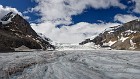
 2 Athabasca Glacier Athabasca Glacier is one of the prime tourist attractions in the Canadian Rockies, readily visible from the Icefields Parkway and visited by thousands every year. Notice the steep lateral moraines on each side of the glacier, which has been shrinking and withdrawing back to the Columbia Icefield for over a century, but is still very large. (If you look at the bottom of the image, about a quarter of the way in from the left, you may be able to see a small path leading up and to the left -- the two tiny specks on it are people walking to the glacier.) |
 3 Athabasca North Glacier Amusingly, this glacier is actually located to the south of Athabasca Glacier. It gets its name from its proximity to the north face of Mt. Athabasca, visible just barely shrouded in clouds on the left side here. The triangular-shaped peak is called the Silverhorn (also slightly obscured by clouds). On the far right, part of Andromeda Glacier. |
 4 Snow Dome and Dome Glacier Snow Dome is another mountain accurately named for its appearance. The mountain's summit is actually located under the Columbia Icefield, and so it appears as a smoothly rounded mountain more reminiscent of what you'd see in the winter in the Appalachians, buried under feet of ice and snow. The small Dome Glacier flows down the valley formed by Snow Dome and Mt. Kitchener. Note the many moraines in this picture: one running along the bottom of the frame from left to center, one arcing in front of the glacier, and another on the right side. Snow Dome is one of two peaks considered by some geologists to be a hydrological apex of North America, because water (mostly snow) falling on it eventually drains into the Pacific Ocean, Arctic Ocean and Atlantic Ocean (via Hudson's Bay). |
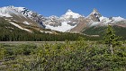
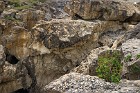 5 Secret Canyon Well, it's not really a "secret", because you can see it easily from near the Icefields Parkway. But it wasn't mentioned in any of our books, nor noted on any maps. There were many interesting eroded shapes and colorful rocks. We didn't explore too far because it was very narrow and somewhat treacherous-looking. |
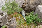 6 Sheltered It's common to find ice and snow in the higher elevations of the Rockies well into the summer, but we were surprised to find this ice in our "secret canyon" at a relatively lower altitude. It persisted, no doubt, due to its sheltered location. |
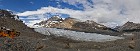 7 The Ice Road This panorama was taken from near the end of the access road to the Athabasca Glacier. It is in this area that tourists disembark from conventional buses and board the special "snocoaches" that go out onto the ice of the glacier. These are buses with very large wheels that can grip the slippery ice, cross rivulets of meltwater, and deal with smaller crevasses that have to be traversed. On the left you can see some of the heavy equipment used to maintain the road; since it is literally made of ice, and the ice melts rapidly to slush in the summer, constant work is required to keep it navigable. There are two snocoaches visible here, one going in each direction; in a larger version of the image you can see two further down the road. The glacier itself can also be seen more readily here, since I was closer to it. Note the "do not walk" signs... nobody will stop you from walking onto the ice if you really wish to do so, but it's dangerous if you aren't familiar with glacier travel. |
 8 Edge of the Glacier The southern edge of Athabasca Glacier, right, with the significant lateral moraine and erosion on the flank of Mt. Andromeda visible left. This is a pretty remarkable image because it looks like it was carefully composed, but was actually taken from the tiny window of a snocoach going about 40 mph! I liked the large rock and was hoping to get it in the corner of the shot, but it came out much better than I had hoped. :) If you look closely you can see some ice under the rock. |
 9 Andromeda Glacier A small hanging glacier in a cirque on the north side of Mt. Andromeda. Apparently at one time this glacier connected to the Athabasca (seen in the foreground here) but has become separated as both have retreated over the last century and a half. |
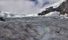
 10 Athabasca Glacier - On the Ice Once the snocoach arrives in the area designated for exploring for that day, you are allowed to disembark and walk around for a while. The view of the glacier is actually worse from on it than from the Visitors' Centre, but the experience of walking on the ice is worthwhile. It's not nearly as slippery as some would imagine, because it is not smooth like ice on a lake -- there's a lot of eroded grit from when the ice passed over rock, so it's more like an icy road after it's been sanded. While we were there we noticed clouds constantly blowing down from above even though it was mostly clear in the valley. The sheer mass of the Columbia Icefield actually "creates its own weather" due to the contrast of the ice and the relatively warm summer air. Also note the surface "river" of meltwater running down to the lower left. |
 11 Glacial Flow The heat of summer causes substantial melting of ice on the surface of the glacier, which collects into small streams that flow down its face. The water itself of course melts more ice, carving the streams deeper and deeper over time, all part of the ever-changing nature of a glacier. I saw a small avalanche on the ridge visible on the right here, a few moments after this image was taken. It was far away, and barely visible, but I still heard it a few seconds after it happened. |
 12 Drinking Ice A close-up of the stream we encountered while on the ice. This is some of the freshest, cleanest water in the world, and glacial meltwater is in fact bottled and sold in the area. |
 13 Athabascan View A wide view from the Athabasca Glacier, with Andromeda Glacier and Mt. Andromeda left, and Snow Dome right. In the foreground, a tourist stoops to fill a water bottle with glacial meltwater. Technically it is not 100% safe to do this, but a lot of people give it a try anyway. The flavor of the water is amazing. |
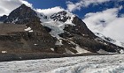
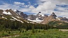 14 Parker Ridge, Mount Athabasca and Hilda Peak You come around a corner on the Icefields Parkway not far from the Visitors' Centre to this beautiful view. Center-right, the distinctive peak of Mt. Athabasca, seen from the south; to its right, Hilda Peak, and between them, Hilda Glacier. On the left, the slopes of Parker Ridge, a popular hiking area that leads to the Saskatchewan Glacier. |
 15 Climbing Parker Ridge A view of Mts. Athabasca and Hilda from about a third of the way up the Parker Ridge switchbacks. The Icefields Parkway snakes northward on the right side. |
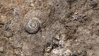 16 Ancient Reminder Small marine fossils can be found readily along the slopes of the Rockies, a good reminder that this high-elevation rock was once underwater. |
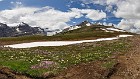 17 Wildflowers Atop the Ridge Cresting Parker Ridge provides the first view of Saskatchewan Glacier, along with pretty alpine wildflowers growing not far from the remnants of the preceding season's snows. Much of this ground is only bare of snow for a handful of weeks in July and August. |
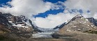
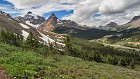
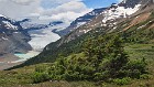
18 Saskatchewan Glacier Valley A wide panorama of the valley that has been created over centuries by ice and water flow from the Saskatchewan Glacier as it descends from the Columbia Icefield. Much of this valley was once filled with ice but the glacier has substantially retreated. The prominent peak in the center behind the valley is called Big Bend Peak. Mounts Andromeda and Athabasca are on the right. Note the tiny green glacial tarn on the far left; you'll be seeing that again shortly. |
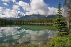
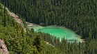 19 Shades of Green The dark green of conifer forest is interrupted by the cool, almost luminescent green of a small glacial tarn in the Saskatchewan Glacier valley. This is the same small body of water at the far left in the preceding panorama. |
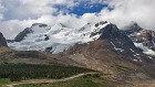
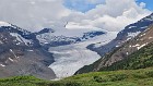
 20 Saskatchewan Glacier Despite its dramatic retreat, the Saskatchewan Glacier is still the largest ice tongue flowing off the Columbia Icefield. Also seen here, some of the stunted trees that are barely able to hang on through the tough winters and short summers on this windy ridge. |
 21 Saskatchewan Glacier Close-up A closer look at the Saskatchewan Glacier, taken from a considerable distance -- perhaps one or two miles -- using a long lens. The word "Saskatchewan" comes from the Cree word "kisiskaciwani-sipiy", meaning "swift flowing river"; this, of course, was initially used to name the Saskatchewan River, a prominent geographical feature of the Canadian prairie provinces. This image shows the toe of the glacier, which is the headwaters of the North Saskatchewan River, the very start of which can also be seen. This river eventually merges with the South Saskatchewan in the province of the same name, then flows east into Lake Winnipeg, and ultimately, Hudson Bay. The peak above the glacier is Castleguard Mountain. |
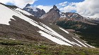 22 Angular The gentle slopes of Parker Ridge contrast with the sharp peaks of Mt. Athabasca and Hilda Peak in this image taken near the middle of the ridge hike, which is short but fairly steep, with a lot of switchbacks. |
 23 Standing Out from the Crowd A couple of small white alpine wildflowers stand out from a sea of smaller lavender ones on a rock on top of Parker Ridge. My botanist friend Janet identified the white flower as dryas octopetala, named for its eight petals. This is actually a flat evergreen dwarf shrub, and has the common names "mountain avens", "white dryas" and "white dryad". The pink flowers are silene acaulis, commonly known as "moss campion". |
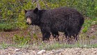
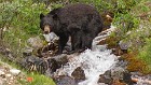 24 Caught in the Act I spotted this black bear right from the Icefields Parkway on a cloudy, gloomy day. The way he (she?) is standing and the facial expression almost make it look like the bear has been caught doing something naughty. It was just frolicking around in the water, though. |
 25 Pensive Black Bear The same bear from the previous image, looking much more serene here. |
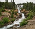
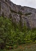 26 The Weeping Wall Small waterfalls plunge down this sheer cliff visible from the Icefields Parkway, creating the impression of streams of tears. The water flow is slight and so the area is not that impressive in the summer, but in the winter these cascades freeze to create towering ice falls, and the very accessible location makes the Weeping Wall one of the most popular ice climbing areas in the Canadian Rockies. The Indian Paintbrush was my consolation prize for being here in the "wrong" season. |
 27 Tangle_Falls This waterfall is formed by Tangle Creek flowing over Tangle Ridge (starting to notice a pattern?) in multiple stages. Honestly one of the most beautiful waterfalls I've ever seen, this spectacle is conveniently located right next to the Icefields Parkway near the border between Banff National Park and Jasper National Park. What I like most about this cascade, which is also called Tangle Ridge Falls and Tangle Creek Falls, is that it is so many different waterfalls in one. The top stage suggests the name, as a "tangle" of small rivulets flows across the rock. The water collects in a small pool before going down three conventional smaller waterfalls. Then the water goes down multiple small steps that remind me more of the sorts of waterfalls we see in the northeastern US. |
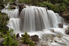 28 Tangle Falls, Middle Stage This smallish fall in the middle of the larger Tangle Falls complex is, I think, the prettiest part. |
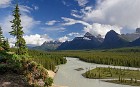
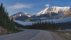 29 Looking Back at Mount Kitchener A less common view from the Icefields Parkway, taken shortly after dawn looking south back in the direction of the Icefields Visitors' Centre. It was a beautiful morning as I drove in and out of valley fog along the parkway. In this image, the dominant peak is Mount Kitchener, rising high above the valley on the right. What appears to be a thick layer of snow on Kitchener is actually the edge of the Columbia Icefield. |
 30 Sunwapta River Valley Panorama The Sunwapta River is a major tributary of the Athabasca River, and nominally begins at the toe of the famous Athabasca Glacier just north of Sunwapta Pass, flowing north towards Jasper National Park. This is a classic view of its river valley from just north of the Icefields Visitors' Centre, showing layers of early morning fog burning off in the July sunshine. From left to right in the background are Stutfield Peak (with a small part of Stutfield Glacier visible), Mt. Woolley (roughly in the centre), and Diadem Peak and Mushroom Peak on the right. |
 31 Fresh Snow in Mid-July Climatologically speaking, the warmest day of the year in most parts of North America is around July 20th. This image, taken July 12, 2004, shows fresh snow dusting the upper slopes of Mount Athabasca (center) and Hilda Peak (right). It literally can snow at any time in the Canadian Rockies! |
 32 Parting Shot A final panorama showing the spectacular view from the Icefields Visitors' Centre. It was really hard to stop shooting, even when I realized I was taking the same images over and over! |
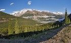
33 Wide View of the Icefields Valley A wide panorama taken at the same time as the preceding image, from across the parkway from Parker Ridge. On the left side the probably-now-familiar cirque of Mount Athabasca and Hilda Peak. On the right, foothills leading up to Nigel Peak. A small glacial moraine can be seen in the foreground, along with some baby conifers struggling to take hold in the often-harsh conditions. |