Jasper National Park
Jasper National Park is the largest of the Canadian Rockies national parks, sprawling across 4,200 square miles. In three or four days one can only really scratch the surface of this magnificent place, but I did my best in this sceneset. Highlights include amazing views of Jasper and surroundings from the top of the Jasper Tramway; various images of Pyramid Mountain, an icon of the park that looms above the town of Jasper; Mt. Edith Cavell and Angel Glacier; the beautiful Maligne Lake and mysterious Medicine Lake; Maligne Canyon and Athabasca Falls.
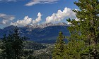
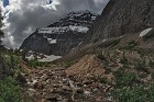
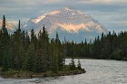
 1 By the Side of the Road A simple shot taken looking north from the side of the Icefields Parkway, shortly after entering Jasper National Park from Banff National Park. It's hard enough to tell what mountain is what without the clouds, so don't ask me what that one is! :) |
 2 Rocky Pond A small, pretty little pond near the Parkway not far from Jasper. The colors and shapes of the rocks were almost mesmerizing. |
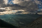
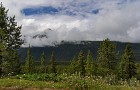
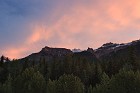
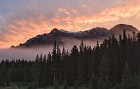
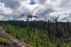 3 Bad Weather Makes Good Photos The title is considered a "maxim" of landscape photography, and it's true to some extent: a perfectly clear day may be great for sunbathers, but it's rather boring for photographers. Of course, a completely cloudy, rainy day isn't so interesting either. It is in between that you get cool conditions, such as seen in this view of clouds breaking and rising from a mountain near Jasper, Alberta. |
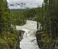 4 Sunwapta Falls The Sunwapta River, which starts as a trickle at the toe of Athabasca Glacier, has become a torrent of collected rainfall and meltwater by the time it gets to this 60' waterfall less than ten miles from the river's source. Sunwapta is a Nakoda (Stoney) Indian word meaning "turbulent water", and the river doesn't disappoint here! |
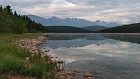
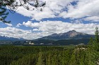
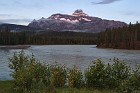
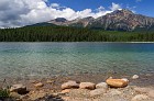 5 Patricia Lake and Pyramid Mountain The day started out cloudy and murky, and showers persisted in the area, but the skies cleared long enough to let the sun light up Patricia Lake and bring out its brilliant blue-green colors. Behind it rises the massif of Pyramid Mountain, an icon of the Jasper area. |
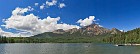 6 Pyramid Lake and Mountain A wide panorama taken from the shore of Pyramid Lake, with the mountain of the same name in the background. Pyramid Mountain is another that was named for its appearance; it looks even more like a pyramid from the east (this view is looking north). The lake is named for the mountain, though it is shaped more like a horseshoe than a pyramid. :) |
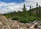
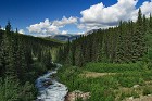 7 Stream Flow A somewhat random scene of the countryside near Jasper, showing a small creek whose name I do not know. |
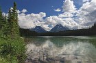 8 Rain on Patricia A shower passing over the Jasper area sprinkles the surface of Patricia Lake. There was a lot of clear sky at this time, as you can see, but the sun was too high in the sky for a rainbow to be visible. |
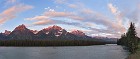
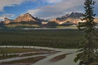
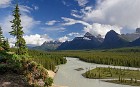 9 Athabasca Lookout A famous view of the Athabasca River and its valley a few miles south of Jasper. The mountains, from left to right: the jagged edges of Dragon Peak; the pyramid-like Mt. Christie, with Brussels Peak capped by a large cumulus cloud behind it; and Fryatt E5, the eastern-most peak of the Mt. Fryatt complex. |
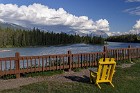 10 Jasper Serenity We stayed at a small motel located right on the Athabasca River a few miles south of Jasper. When you're in a place like this, all you really need is a chair... |
 11 Base of the Tramway For those not into a major mountain climbing experience, the Jasper Tramway lifts tourists over 3,000 feet to near the top of Whistler's Peak, just southwest of the Jasper town site. Even at the base (where this photo was taken) you are already several hundred feet above the town below, but it's nothing compared with the top. |
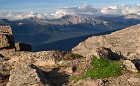
 12 The Maligne Range A view of the Maligne Range from near the top of Whistlers Peak, near Jasper. The range is named for Maligne Lake, which is located to its east, on the other side of the peaks from where this was taken. Mount Kerkeslin is the highest summit in the range, visible at the right end of the chain of peaks here. Signal Mountain is at the left end. |
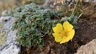
 13 Whistlers Peak Like Whistler Mountain in southwestern British Columbia, Whistlers Peak was probably named for the sound made by the hoary marmot, a large rodent found all over the higher elevations of the Rockies. (You can see a picture of one in the Yoho National Park - Lake O'Hara sceneset.) Mosses with pretty, short-lived summer flowers thrive here as well. The Colin Range looms in the background. |
 14 Unexpected Color This single yellow flower on the top of the mountain took me a bit by surprise. It was amazingly cold up there even in July, and I would imagine the growth rate of the vegetation up there is very slow. |
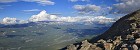
 15 Sunrays Over the Victoria Cross Range Sunrays filter through low clouds a few hours before sunset in this panorama looking west from the terminus of the Jasper Tramway. Rolling hills lead to the Victoria Cross Range, whose most famous member, Pyramid Mountain, shows the reason for its name clearly on the right side here. The road running from the center bottom the upper left is the Yellowhead Highway, which crosses the Continental Divide at Yellowhead Pass in this image and heads to Robson Provincial Park. It is actually possible that Mount Robson is in this image, on the left somewhere, but I'm not sure. |
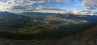 16 Jasper from Above Jasper, Alberta and the surrounding countyside, seen not far from sunset from the top of Whistlers Peak. The town's distinctive arrowhead or chevron shape can be seen clearly from this elevation. On the far left, Pyramid Mountain, and to its right the peaks of the Colin and Maligne ranges. The Athabasca River winds through the valley south of Jasper (to the right), while the Miette River can be seen coming in from the northwest (left). |
 17 Pre-Dawn Purple The blue of pre-dawn combines with the pink of the rising sun to create purplish clouds over the Athabasca River. Taken at some ungodly hour when I should have been sleeping and the sun should have been more visible. |
 18 First and Last Light of the Day In an act of pure optimism, I went out looking for the sun this particular morning, even though I knew it was likely to be cloudy. I never got a brilliant sunrise, but a few rays did sneak below the overcast long enough to light up these clouds over the Athabasca northeast of Jasper. This was, unfortunately, both the first and last light of the day, which quickly became dark and miserable -- we even got some fresh snow on the mountaintops. |
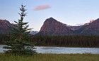
 19 Patricia Lake Reflections Patricia Lake was like a mirror on this cloudy, still morning. |
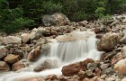
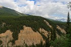 20 Hoodoos Under Development This cliffside shows regular patterns caused by rain and melting snow. It is possible that in time the triangle shapes will separate from the cliff and form small hoodoos, similar to those seem in certain other areas of the Rockies. Pyramid Mountain can be seen in the distance far right, poking up out of low clouds. |
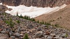
 21 Rockfall A small, unnamed, yet undeniably pretty waterfall on a rocky stream not far from Mt. Edith Cavell. |
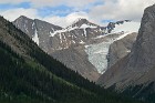
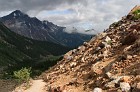 22 Path of the Glacier The Path of the Glacier is a relatively short, easy hike that allows nearly anyone to get "up close and personal" with a glacier -- in this case, the Cavell Glacier, which sits at the base of Mt. Edith Cavell. This image shows part of the trail looking back towards the parking area. |
 23 Mount Edith Cavell There are many mountains in the Canadian Rockies named for people -- usually explorers or those who sponsored them. Mount Edith Cavell, however, is named for a British nurse who rose to fame during World War I, when she helped over 200 Allied soldiers escape occupied Belgium. She was tried for treason and executed by the German authorities as a result; because of her bravery she became a famous figure who was memorialized in many ways, including the naming of this impressive peak in 1916. This wide stream carries meltwater from Mt. Edith Cavell and its glaciers. The "left wing" of Angel Glacier can be seen center right, about two-thirds of the way up the mountain. |
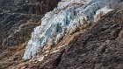
 24 Triangles While walking on the Path of the Glacier, I was struck by the triangular shapes created by the rocky slopes and the Cavell Glacier itself, part of which is visible in the background. |
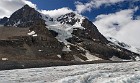
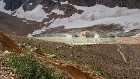 25 Approaching Cavell Glacier Cavell Glacier is a small body of ice located in the bottom of the valley near the base of Mt. Edith Cavell. Icebergs regularly break off from its toe and float around in the green-gray pool that forms around the glacier in the warmer months. This is how the glacier appears as you approach it on the trail (visible far right, to give you a bit of a sense of scale here.) |
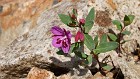 26 Dwarf Fireweed Fireweed is so named because it is one of the first plants to colonize areas after a forest fire. It also grows readily in other barren places, such as rocky outcroppings, as seen here. It was quite abundant in the Cavell Glacier area. |
 27 Angel Glacier One of the most distinctive glaciers of the Canadian Rockies, and another natural phenomenon named for its appearance. This image was taken looking up from well below the glacier, so it's not as easy to see the "angel" shape, though you can still make out the "left wing", "right wing" and "body". Angel Glacier was named in the 1800s, when it was much larger. Like all Canadian Rockies glaciers, it is shrinking; since it was never very large to begin with, this glacier may completely disappear within a few decades. |
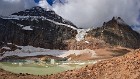 28 Angel Glacier and Cavell Glacier Clouds drift over the summit of Mt. Edith Cavell above Angel Glacier and Cavell Glacier. A century ago the two were connected, but glacial retreat has separated them. Angel Glacier is located in a cirque on the flank of Mt. Edith Cavell; you can just barely make out the cirque from this location, but need to be higher up to view it properly. Rivulets of meltwater can be seen flowing down from Angel Glacier, feeding the pond which dozens of icebergs from Cavell Glacier float during the summer months. |
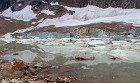 29 Cavell Icebergs In warmer weather, water from melting snow and ice collects in a basin near the terminus of Cavell Glacier, which then calves off icebergs. This water is sometimes called "Cavell Lake", but that actually refers to a real lake located somewhat north of here. The stripes in the glacier are formed by alternating layers of ice and dirt that settle seasonally -- ice in winter, dirt in summer -- making the glacier look almost like an oddly-colored salmon filet. Notice the ripples in the pool, which were not caused by a thrown rock. Part of what makes icebergs so dangerous is that sometimes they melt more rapidly on the bottom than the top; this makes them unstable, and they can flip over without warning, as occurred here just before I captured this image. |
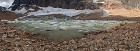 30 Cavell Glacier and Pool A panorama of the Cavell Glacier and its pool, with the very toe of Angel Glacier visible at the top, center-right. Though difficult to make out, there's a hiker near the far right edge of this image (wearing a white top and black pants) to give you some sense of scale here. |
 31 Angel Toe The farthest exent of a glacier is called its toe, and this image shows a close-up of the toe of Angel Glacier, taken from a significant distance away. Note the small waterfall of summer meltwater, center bottom. |
 32 Pyramid Mountain from Maligne Road Overlook Near the start of the relatively long road that leads to Maligne Lake from Jasper, there's a pulloff with a nice view looking back towards the town. From here it is very easy to see how Pyramid Mountain got its name. |
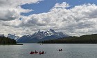 33 Paddling Maligne Lake Maligne Lake is the largest body of water in Jasper National Park. Long and thin, it stretches for 14 miles in a narrow valley between Rockies mountain ranges at an elevation of roughly 5,500 feet. The name "Maligne" may have been given to the lake -- along with a river, mountain and other places in the area -- by French explorers; the word means "wicked" in French. The two large peaks here you can see Mt. Charlton (left of center) and Mt. Unwin (right of center). Near the far left in the back is Mt. Warren. |
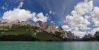 34 Maligne Lake Panorama A panorama of the north shore of Maligne Lake, taken quickly from a speeding boat on its way down the lake to Spirit Island. The lake has the distinctive blue-green color of lakes in the Rockies. The sharp peak center-right is Mount Paul; right of it is the distinctively saddle-shaped Mount Warren. |
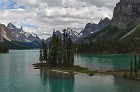 35 Spirit Island If you were to compile a list of islands ranked by the ratio of their size to the number of pictures taken of them, this tiny speck of land in the middle of Maligne Lake could well take the prize. :) It is sufficiently famous that it has become the "turnaround point" for boat tours of Maligne Lake, roughly eight miles from the boat house on the lake's northwest shore. It really is a beautiful place, though unfortunately the lighting conditions were rather humdrum at the only time we were able to get a tour. (Like many locations, it is best photographed at sunrise, but you'd have to paddle there yourself and camp overnight to see it at that hour.) What's really ironic about Spirit Island is that technically it isn't an island at all. It's connected to the mainland by a tiny strip of land, so it's actually a peninsula. |
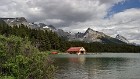
 36 Maligne Glacier One of three glaciers visible from Maligne Lake, Maligne Glacier flows down from Maligne Mountain (which is behind the peak on the right edge of this image, not visible from the lake). Note the classic "U-shaped" slope of the glacial valley wall in the foreground. |
 37 Maligne Lake Boathouse Another icon of the Canadian Rockies -- better captured at dawn or dusk, but hey, you can't have everything, and with the weather we had, it might not have made a difference. :) Leah Peak is at center right here, with Samson Peak far right. |
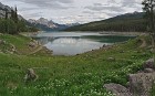 38 Medicine Lake Approximately half-way between Jasper and the northwest tip of Maligne Lake lies the curiosity known as Medicine Lake, which varies dramatically in appearance depending on the time of year. In early July the lake is full, as it appears here, but by the end of the summer this vantage point would show a large mud flat with small streams running through it. This has always intrigued those who have encountered the lake, and may be the source of its name (which is analogous to the term "medicine man", referencing the spirit world or the supernatural, not medicine as in pills.) Scientists investigating this phenomenon discovered that Medicine Lake is not really a lake at all. It's essentially a flood basin, where the Maligne River dramatically widens when it hits an area where the river is forced underground, and thus is bottlenecked. During the spring and early summer, runoff from rains and melting snow raise the level of water in the basin until it forms what looks like a lake, like a bathtub whose tap fills it faster than the water can drain. Over the course of the summer, the inflow to the "lake" decreases while the underground flow of the river continues, draining the area. If you go to Google Maps and look at satellite images of this region, you can sometimes see the "lake" in various stages of fullness as you change the zoom level. |
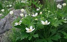 39 Simple Flora The northern end of Medicine Lake was carpeted with these pretty white flowers; you can see them in the foreground of the preceding image. |
 40 Mount Kerkeslin Near Sunset Mount Kerkeslin is not the highest peak in the Maligne Range, but is one of the most prominent, being easily visible from the Athabasca River Valley. This is one of the few mountains in the Canadian Rockies for which the derivation of the name is not known -- modern historians aren't sure who (or what?) Kerkeslin was. |
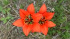 41 A Splash of Orange The brilliant orange of the wild lilies that grow near the roadside in the Rockies provides a vibrant contrast to the muted grays and greens of an overcast day. |
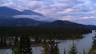
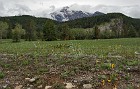
 42 Roadside Scene Clouds breaking up over the mountains near the Icefields Parkway, south of Jasper. |
 43 Fresh Snow on Pyramid Mountain It snowed more than once on this July trip... pretty much any time we had a cold rain in the valleys, there would be some snow dusting the peaks around us, which generally melted the next day. |
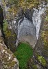
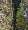 44 Maligne Canyon Maligne Canyon is a deep gorge located just east of Jasper, which has been carved by the Maligne River over the course of centuries. One of the most popular natural attractions in Jasper National Park, it has many interesting rock shapes, cascades and waterfalls. Generally quite narrow, the canyon walls descend as much as 50 feet down to the water. |
 45 Maligne Canyon Pothole As rivers flow through canyons, they sometimes form eddies that, over time, carve out rounded hollows like this one, which are commonly called "potholes". The base of this one has filled in with vegetation, likely because the river's erosion of the underlying rock has dropped it too low to spill into this area any more. |
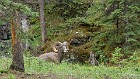 46 Bighorn Sheep at Maligne Canyon A herd of bighorn sheep makes its home near Maligne Canyon. They seem to be very docile, and don't even react when people walk by on the pathway leading to the canyon. That said, it's still important to remember that these are wild animals, and not to approach them -- those horns look painful. |
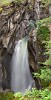 47 Maligne Falls Okay, this is actually pretty funny. I had no idea what this waterfall in Maligne Canyon was named when I started this description, and I was just going to say that I decided to call it "Maligne Falls" since it seems like everything else in the area has "Maligne" in the name. But for fun, I decided to research it, and it turns out that that's its real name! |
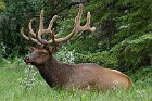 48 Majestic Bull Elk A very nice specimen of the native elk abundant in the Canadian Rockies. |
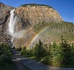
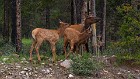 49 Doe and Fawns It would be cute if these three elk and the bull of the preceding image were a "family", but they were actually photographed in different locations. |
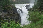 50 Athabasca Falls Athabasca Falls is an impressive sight any time of the year, but especially so in late spring when melting snow and ice swells the Athabasca River. The waterfall is not especially high, but it is wide, and the volume of water that goes over its brink makes a thundering noise that can be heard from quite a distance. |
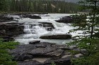 51 Cascades Above Athabasca Falls While not as awe-inspiring as the main waterfall itself, I think these small step cascades above the brink of Athabasca Falls are more picturesque. |
 52 Alpenglow, Mount Christie The first light of morning bathes the iconic Mount Christie in a purplish glow, on the only morning we were in Jasper National Park that the skies were clear enough to enjoy the sunrise. |
 53 Early Glow The sun illuminates wispy clouds over the Maligne Range, southeast of Jasper. |
 54 UFO! Lens-shaped lenticular clouds often form over mountain ranges under the right weather conditions, and are believed to be the cause of some UFO reports. This small, oval-shaped cloud isn't a lenticular, but reminded me of them as it hovered over the mountains at sunrise just south of Jasper. |
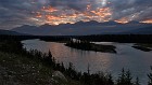
 55 Sunrise in the Athabasca Valley We had originally planned for four days in Jasper National Park, during which I figured it was almost certain that I'd get some nice, clear weather at sunrise at least once. Wrong! Weather being what it is in the Canadian Rockies, it didn't pan out, and I was disappointed. The final night of our trip was down in Kootenay National Park, several hours from Jasper, but I really wanted to catch a sunrise, and noted that the weather was supposed to clear. So I got up at 2:00 am and drove all the way back to Jasper, got there just in time for sunrise, and photographed my way all the way down the Icefields Parkway. I ended up staying up 20 hours straight and doing a lot of driving, in a night I won't soon forget. It was totally worth it. :) Here's one of the shots (actually a stitched panorama) I took that morning not far south of Jasper, showing pretty morning clouds and early light on Mount Fryatt, Geraldine Peak, and in the distance, Mt. Edith Cavell. |
 56 Spectacular Sky The color in the sky this early morning was really incredible. A band of broken clouds was hanging over the mountains east of the Icefields Parkway, and it lit up in amazing shades of purple, red, orange and yellow. This image doesn't even really do it justice, but it gives you an idea. I believe that is Mt. Hardisty. |
 57 Bands Cloud bands in the sky and floating in the Athabasca Valley create interesting patterns of light and shade on the mountains of Jasper National Park shortly after sunrise. |