Yoho National Park
Supposedly, the name "Yoho" comes from a Cree Indian word that expresses amazement -- at least, a lot of websites seem to think so. Once you visit the park, though, it's easy to believe. In fact, I think Yoho is probably the most underrated of the Canadian Rockies national parks -- it is every bit as pretty as Banff and Jasper, but seems to be much less well-known. Located just on the other side of the Continental Divide from the Lake Louise area of Banff National Park, the highlights of Yoho include a natural bridge, the staggering heights of Takkakaw Falls, and a personal favorite, Emerald Lake. Yoho is also home to the unique Lake O'Hara high alpine region, which is covered in a separate sceneset.
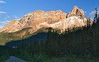
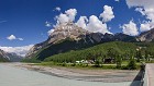 1 Welcome to Field Field, British Columbia, is the only "major" town in Yoho National Park, and "major" is really being generous. A beautiful little village of approximately 300, it consists of just a few dozen small homes and a handful of small motels, accessed by a bridge over the Kicking Horse River, which you can see part of on the right in this panorama. Cathedral Mountain is the prominent peak rising behind the town. |
 2 Natural Bridge A couple of miles west of Field on the road to Emerald Lake, the Kicking Horse River has carved a natural bridge out of the rock. It is possible to walk across the span, but I believe tourists are requested not to do so. The volume of water flowing in the river at the time were there provided additional incentive to respect that request! |
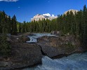 3 Natural Bridge 2 Another shot of the natural bridge. This one was taken in early evening, so the lighting is the opposite of the prior image, with the falls in shadow and Cathedral Mountain lit up in the background. |
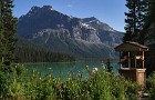
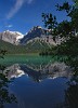
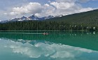
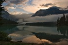
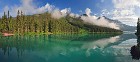
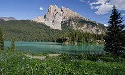 4 Mount Burgess and Emerald Lake Emerald Lake is appropriately named: a gen of a lake with greenish-colored waters, it was one of my favorites of the Rockies. This image was taken from the lake's northwest shore, looking southeast towards Mount Burgess. In the middle ground, the beautiful -- and pricy -- cabins of the Emerald Lake Lodge. Mount Burgess is famous in fossil circles. The Burgess Shale is a formation discovered in the early 20th century quite high up the peak by paleontologist Charles Doolittle Walcott; it contains some of the best-preserved specimens of soft-tissue fossils ever discovered. |
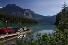
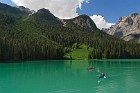 5 Flying Canoes Like many glacial lakes, Emerald Lake's waters are cloudy and a beautiful green-blue color because of the constant inflow of fine glacial silt called rock flour. The opacity of the lake makes boaters seem almost like they are actually flying above its surface. |
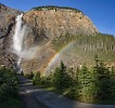 6 Rainbows at Takkakaw Falls Takkakaw Falls is either the second- or third-highest waterfall in Canada, depending on whom you ask. If you arrive at the right time in the early evening, the setting sun paints the cliffs with golden light and creates a bright rainbow in the spray from the falls. I didn't actually know this at the time, so I guess here we have another example of the old saying that it's better to be lucky than to be good. :) The falls don't actually appear that high from this distance, partially because the water actually spurts outwards about a quarter of the way down; the cascade is actually over 1000 feet high. |
 7 Moon Over Yoho Valley Road Yoho Valley Road is the long, winding ribbon of (mostly) pavement that leads to Takkakaw Falls. It's a beautiful drive, but narrow enough that it is wise to pay at least as much attention to driving as looking at the scenery. This early evening image shows the nearly-full moon peaking out from behind one of the many majestic peaks in the area, but I am not sure which one this is. It could be Wapta Mountain. |
 8 O Canada A small Canadian flag, nestled among similarly-colored canoes on the boat dock at Emerald Lake, overlooks another clear, calm morning. |
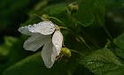
 9 Emerald Well I found these flowers and rustic wooden well near the start of the Emerald Lake Trail, adjacent to the cottages of Emerald Lake Lodge. |
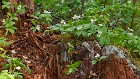 10 Wet Dogwood Emerald Lake has an interesting climate because of its location. The northwest shore is in a rain shadow caused by adjacent tall mountains, and is thus very dry; the opposite, southeast shore, is much wetter. You can probably tell where this image was taken; these dogwoods were persistently taking root anywhere they could find. |
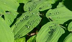 11 Beads The leaves of this plant seemed to be coated with a waxy substance that caused water droplets to bead up and roll off. |
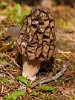 12 Black Morel One of the interesting flora encountered on the "wet side" of the Emerald Lake loop trail in Yoho National Park. These are supposed to be highly prized by gourmets, but not being mushroom experts -- and not wanting to disturb the natural environment -- we stuck to trail mix. |
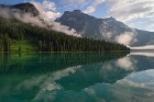
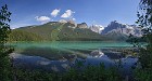 13 Emerald Lake Panorama The crystal clear green waters of Emerald Lake reflect a series of mountains northwest of it. From left to right: Emerald Peak, Top Hat Peak, Mount Marpole, and some of the shoulder peaks of the President and Vice President. I could be wrong about some of those mountain names -- it's hard to tell from maps and photos. |
 14 Ripples An insect or falling debris from a tree branch created these small ripples in Emerald Lake, disrupting the mountains' reflection for a moment. |
 15 Wet and Wild Rose Wild roses are abundant on the wet side of Emerald Lake. |
 16 Beatuiful Morning for a Paddle A couple of canoers set out for a paddle across Emerald Lake; the lodge of the same name is seen to the right. |
 17 The Alluvial Fan Northeast of Emerald Lake is an alluvial fan almost as large as the lake itself. This is a large mostly flat area where runoff from glacial melt and erosion of the mountains has deposited a large amount of soil and debris, with small meltwater streams running through it. The Emerald Lake Trail cuts across the fan, using boardwalks and bridges in the wettest spots. |
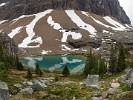
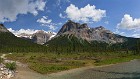 18 Michael Peak Michael Peak is located north-northeast of Emerald Lake, and is visible across the alluvial fan from the lakeshore trail. Behind it is, I believe, part of Emerald Glacier. |
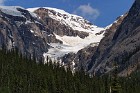 19 Emerald Glacier A close-up of Emerald Glacier, taken from a considerable distance away using a long lens. I believe this glacier is nestled between the two peaks called the Vice President and President, named by explorer Edward Whymper for top executives of the Canadian Pacific Railway, who sponsored his pioneering efforts. |
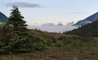
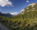 20 Yoho Valley Another beautiful alpine scene from the Yoho Valley in Yoho National Park. |
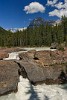
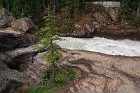 21 Watch Out for the Kicking Horse For a 19th century Rocky Mountain explorer, every mountain, hill river and lake encountered was a blank slate. (They had Native American names, sure, but nobody cared about those.) Most prominent features were named after royalty, dignitaries, or family or friends of the explorers; some were named based on their appearance (such as Castle Mountain); and some got really weird names. In 1858, a pack horse owned by explorer James Hector fell into this river. In trying to get the horse out of the water, Hector was kicked in the chest, and so the Kicking Horse River was named. :) |
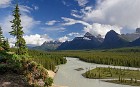
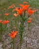 22 Field Lilies Wild lilies growing not in a field, but right by the side of the Trans-Canada Highway, just outside Field, British Columbia. |
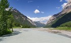 23 The River Widens Starting out as a small stream from its source at Wapta Lake, the Kicking Horse River widens dramatically when it gets near Field, British Columbia, the "major" town in Yoho National Park (it's pretty small!) |
 24 Dawn Rising The first morning light hits peaks north of Field, British Columbia, as a beautiful day dawns in Yoho National Park. |
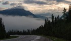
 25 Shrouded Canada Day 2004 was a wet one in the Canadian Rockies, and the next day started out gloomy and foggy. Low clouds shrouded the mountains and valleys, but started to break up as the sun rose. The ripples in the sky center-right are called gravity waves, and are caused by turbulent flow over the mountain ranges. |
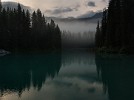
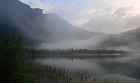
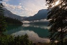
 26 The Forgotten Pole We discovered after our hike of Emerald Lake that our middle son had left his hiking pole on the trail. I was annoyed about having to leave it behind, so decided to get up early and trek back up to the lake and head out around the shore to see if I could locate it. I never did find the pole, but I was rewarded instead with incredibly beautiful early morning conditions: still water with fog blowing over it, variable clouds and the sun breaking through. |
 27 Spooky Pines Early morning fog gives Emerald Lake an otherworldly appearance in a color image that appears almost monochrome due to the conditions. |
 28 Loony As if the conditions weren't already amazing enough this fine morning at the lake, I heard a splash and discovered a loon swimming in the water not far away! It was truly a magical moment I can still remember vividly a decade later, and was also the only time I encountered a loon during my entire time in the Canadian Rockies. |
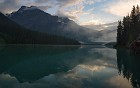 29 View from the Dock Another view of Emerald Lake and Emerald Peak taken on the same beautiful morning as the preceding shots, this time from the boat dock. There's actually a water bird of some sort standing in the water far right, but it's hard to see unless you look closely at a full-resolution copy. |
 30 Breaking Through Taken about an hour after I arrived at Emerald Lake, by this time the sun had broken through the clouds and much of the fog had already burned off. |
 31 Trans-Canada Quiet The Trans-Canada Highway bisects Yoho National Park, and is often busy with traffic -- but not at 6 am. |
 32 Lifting Fog, Emerald Lake This wide panorama showcases a full view of Emerald Lake on a spectacular morning, the early sun burning off the fog that had settled onto the water after a solid day of rain. The Emerald Lake boat house can be seen far left while the purple flowers far right are hanging from the small bridge that you traverse to get to Emerald Lake Lodge. |
 33 Lifting Closer A closer view of the mountains in the preceding image, featuring Emerald Peak. |